
Gendarmerie : système de cartographie de crise
Instrumentation d’hélicoptères de la gendarmerie avec un système embarqué de cartographie de crise (SC2)


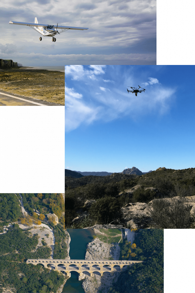
From the design of compact embedded systems to photogrammetric and lidar processing to the development of image processing algorithms, L’Avion Jaune has mastered all stages of aerial data production.
The high resolution of its multispectral images gives you access to the information you need – from temporal monitoring of agricultural land or natural areas to spatial analysis and 3D data.
L’Avion Jaune is committed to supplying more than just photos. We supply aerial images processed to obtain quantitative information for photo-interpretation and remote sensing.
Instrumentation d’hélicoptères de la gendarmerie avec un système embarqué de cartographie de crise (SC2)
Lightweight aerial imagery gives you an accurate representation of spaces and the environment beyond the visible. L’Avion Jaune provides you with all its know-how in order to respond effectively to the issues of the most complex projects. Visible and multispectral orthophotographs, digital surface models (DSM), digital terrain models (DEM), point clouds, 3D meshes, NDVI maps, thermography: our team will be able to advise you and provide you with the most suitable products for your profession. Always ready to take up new challenges and committed to an active research and development approach, we can also offer you innovative and tailor-made mapping solutions in multirotor drones, light aircraft or fixed-wing drones.
Entre 2016 et 2019, L’Avion Jaune a effectué des missions de prise de vue unique sur l’altiplano Bolivien, dans la région d’Uyuni. Cette zone située à 4000m d’altitude est depuis des siècles productrice de quinoa. Elle possède un patrimoine archéologique unique encore très peu étudié et encore moins cartographié. Des vues faites par cerf-volant et drone, ont permis de récolter des données inédites pouvant générer des modèles 3D qui ont permis une nouvelle compréhension de cette organisation agricole et sociale. Une mine d’informations pour les chercheurs Français et Argentins qui en ont tiré des articles remarqués par la communauté scientifique.
vecteurs
sites couverts
de résolution
d’altitude de vol
« L’intéret du projet est d’une part anthropologique pour comprendre comment les sociétés ont pu interagir avec le milieu très rude et avoir une production avec des excédents, et d’autre part un intérêt patrimonial pour la Bolivie pour faire connaître cette région encore mal connue. Il y a aussi un intérêt méthodologique, plus large pour l’archéologie, qui est de tester et mettre en place une méthode permettant de cartographier ces milieux hostiles, avec fiabilité et rapidité, à partir de la photographie aérienne. Cette méthode que nous sommes en train de mettre en place avec L’Avion Jaune porte donc un intérêt pour la recherche archéologique sur les hautes terres Andines »
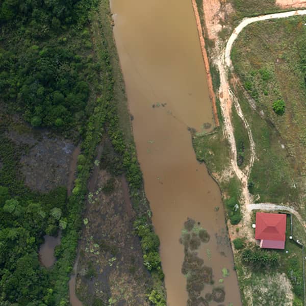
Dans les pays producteurs au climat équatorial, où la couverture nuageuse ne permet pas l’utilisation des données satellites ou avion, L’Avion Jaune a développé, à la demande d’OLAM international, une solution basée sur le déploiement d’une aile volante permettant de cartographier des dizaines de milliers d’hectares en quelques heures. Les images multispectrales acquises permettent non seulement d’avoir une vue complète de l’ensemble de la plantation mais aussi, grâce aux techniques de DeepLearning, d’extraire des paramètres bio-physiques à l’échelle de l’arbre : comptage automatique des arbres, estimation du diamètre de la couronne, état de santé de l’arbre…
Drone à voilure fixe
de charge utile
d’endurance
vitesse
d’altitude maximum
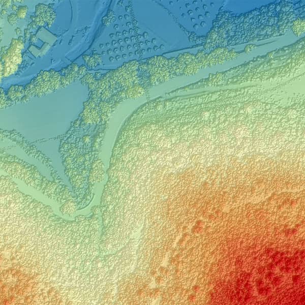
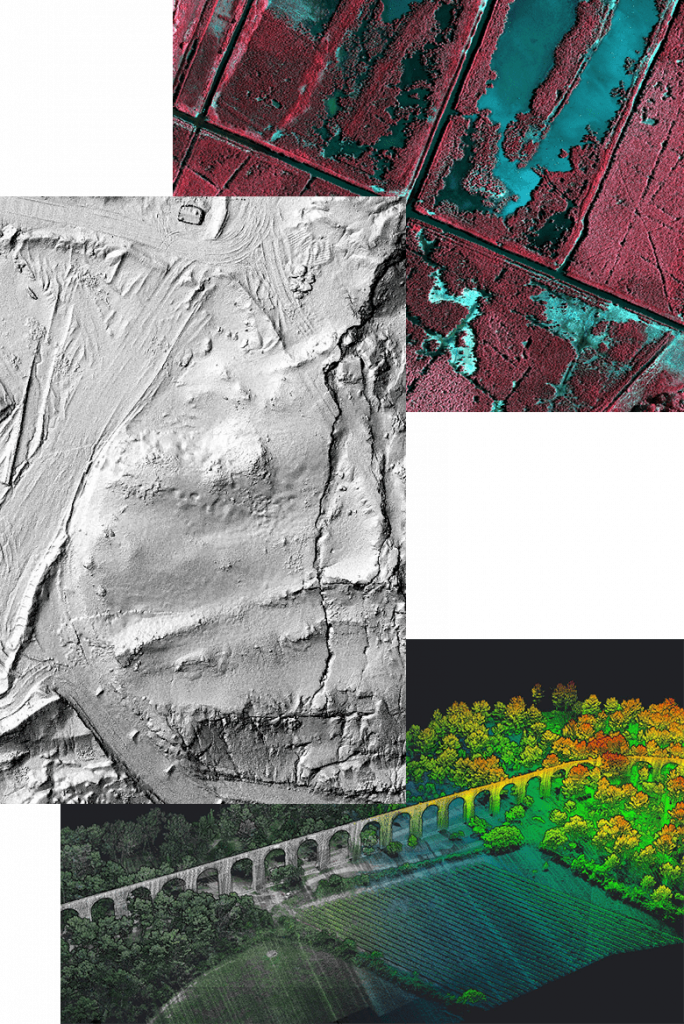
La technologie, oui, mais pourquoi ? Il est important de se rappeler que les moyens techniques que nous mettons en œuvre au quotidien servent principalement à l’aide à la décision pour la gestion durable des territoires. Un bel exemple de cette application de nos travaux s’est déroulé aux Mées, une commune des Alpes-de-Haute-Provence de 4000 habitants, frappée par un violent éboulement en décembre 2019 qui a causé la destruction de trois habitations, heureusement sans faire de victime. En novembre 2020, L’Avion Jaune a été missionné par la Direction départementale des territoires pour produire des levés lidar & photogrammétriques sur les Pénitents des Mées. Ces cartes 3D sont un atout majeur pour les opérations de sécurisation immédiates et de gestion des risques résiduels. Sur le plus long terme, nos travaux se présentent comme un outil performant pour optimiser l’actualisation du Plan de Prévention des Risques de la commune.
jours de terrain
vols drone
images
de résolution
points LIDAR
Depuis 2013, L’Avion Jaune et son partenaire Fruition Sciences, proposent un service complet destiné aux viticulteurs et aux consultants agronomiques désireux d’intégrer à leurs process des outils d’aide à la décision basés sur la cartographie de vigueur. Des photographies aériennes, prises aux stades clés du développement permettent de visualiser les variations d’expression végétative des vignobles.
Pour optimiser la rentabilité du vignoble, il est vital de faire le point sur les anomalies ou les différences de vigueur intra ou extra parcellaire. Les causes sont multiples, type de sol, maladies, l’exposition, les pratiques culturales…
Ainsi, les traitements spécifiques développés par L’Avion Jaune associés à l’expertise agronomique de Fruition Sciences permettent de mieux comprendre les vignobles afin de révéler tout leur potentiel. Ainsi, les viticulteurs peuvent découvrir ce qui est impossible de distinguer à l’oeil nu. Les zones à problèmes pourront ainsi être traitées rapidement, de façon optimale et ciblée.
Toutes les données recueillies sont visualisables de manière simple, intuitive et accessible grâce à une interface web intégrée au service !
survolés chaque année
de résolution
« La photo NDVI est le seul moyen actuellement d’avoir un instantané de la vigueur de la vigne sur l’ensemble de notre vignoble. Elle permet un gain de temps par rapport à l’observation de terrain pour identifier des variabilités intra parcellaire. Cela nous permet l’année N de faire des vendanges sélectives mais également l’année N+1 d’adapter la taille et la fertilisation. La photo NDVI du mois d’août N+1 permettra de voir l’impact de nos choix techniques »
Philippe Stoeckle
Directeur technique de Chateau Olivier (Pessac-Leognan)
« L’utilisation du NDVI nous donne une vision globale et détaillée du vignoble. Si elle est couplée à des observations visuelles et des analyses de référence, elle nous permet un travail beaucoup plus précis de découpage de nos terroirs »
Benjamin Vimal
Directeur technique de Chateau Lagrange (Saint-Julien)
La Camargue est un milieu naturel et mixte dont l’évolution est sous surveillance rapprochée. Il est en effet fragile et des aménagements sont entrepris pour le préserver. Le cabinet Alisé Géomatique a en charge d’en dresser l’état des lieux.
superficie couverte
de résolution
d’altitude de vol
vecteur et capteur
« Cette deuxième acquisition, pour cette nouvelle mise à jour que nous avons menée pour le PNR de Camargue, a permis une parfaite maîtrise des dates de prise de vue. Nous avons donc pu planifier un contrôle terrain, le même jour que la prise de vue, ce qui est précieux, pour apprécier le stade de certaines cultures (prairies fauchées ou non par exemple). La qualité radiométrique des images ortho-rectifiées, étaient au rendez-vous ce qui nous a permis de distinguer les 52 postes de cette nomenclature très riche, par photo-interprétation manuelle des clichés. Le client a donc été livré de cette mise à jour en 2016 de son occupation du sol, en Août 2016, seulement 2 mois après l’acquisition de l’image, ce qui est inédit, à ce niveau de finesse. »
En cas de crise locale il est important pour la gendarmerie nationale de disposer très vite (moins de quatres heures) de cartes imprimées à distribuer à ces agents afin de pouvoir organiser les moyens au sol. L’Avion Jaune a donc mis au point un dispositif pouvant se monter sur hélicoptère et permettant de créer les données voulues. Une performance en terme d’efficacité qui rendra service en de nombreuses circonstances, comme les catastrophes naturelles ou industrielles.